
The sound before the slide
In March 2014, a large landslide occurred at Oso, northwest Washington, USA, killing 43 people and destroying about 50 homes and other structures, as well as nearly a mile of State Route 530. US Geological Society research indicates that the landslide’s average speed was about 40 miles per hour, with maximum speeds likely even higher. The area overrun by the landslide was about one-half square mile, and the landslide moved about 18 million tons of soil. The hazards associated with the slope were known but inadequate risk reduction methods were implemented, and this resulted in significant loss of life and damage to the town. It is possible that monitoring instrumentation installed across the slope, such as acoustic emission systems, in conjunction with pre-established response strategies, could have allowed early warning to enable evacuations
Did you know?
🔊 Acoustic emissions to monitor underground movement
- Friction between soil particles rubbing against each create the acoustic emissions that warn of ground movement
- Movements in the ground can cause hundreds of millions of pounds worth of damage to buried infrastructure such as pipelines and tunnels
- Technology that detects the acoustic emissions before a landslide could also be deployed to monitor underground movement
The noise created by a landslide – a variable cacophony of roaring, rumbling and crashing – is terrifying, but transient. The slide itself, over in just a few minutes, represents the spectacular climax to a process that may have been building over days, weeks or even months. This precursor phase is also accompanied by sound. Inaudible to the human ear, the tiny ground movements that precede a full-blown slide generate high-frequency vibrations: ground-generated acoustic emissions. If detected, these vibrations can serve as an indication of disaster in the making.
Landslides, while responsible for large numbers of deaths in some parts of the world, can hardly be described as a ubiquitous risk. Buried infrastructure, by contrast, is everywhere: rail and road tunnels; pipelines carrying oil, water or gas; dams; the foundations of structures ranging from bridges to wind turbines; and much else. All these structures are susceptible to damage resulting from movements in the ground that both surrounds and supports them. The UK spends 100s of millions of pounds each year maintaining infrastructure, and this will grow significantly as existing infrastructure ages and more is constructed. However, this spend could be an order of magnitude lower if deterioration is detected early enough using early-warning systems. The UK’s existing, ageing geotechnical assets comprise around 10,000 kilometres of rail track; 46,000 kilometres of metal water and energy pipelines; 1,800 offshore wind turbines; hundreds of kilometres of tunnels; and 100,000 bridges, retaining structures and foundations.
The UK spends 100s of millions of pounds each year maintaining infrastructure, and this will grow significantly as existing infrastructure ages and more is constructed.
Now, engineers at Loughborough University have developed a practicable method of detecting ground-generated acoustic emissions. The instrument they’ve developed is a useful addition to several other technologies already deployed for landslide warning, each with its advantages and limitations. Looking to the future, Loughborough’s research on landslides could also lead to a much wider application of these acoustic emissions when detecting ground movement around buried infrastructure.
Detecting miniscule movements in the soil
The movements of soil particles in unstable ground before a landslide are vanishingly small, but even the slightest displacement will cause these particles to rub against their neighbours. It is this interparticle friction that generates acoustic emissions. The greater the ground movement, the more each particle will grind against its neighbours, and the more the sound emitted.
One of the hurdles geotechnical engineers have detecting these sounds is that they are poorly transmitted from particle to particle through the ground and, even more challenging, is that their principal source lies well below the surface. Watch a landslide in action and you will see an upper layer of material sliding over a more stable layer. The intersection between the two, the shear plane, is also the region where, before the main slide begins, there is the greatest movement between soil particles, and so the generation of the most intense acoustic emissions.
Neil Dixon, Professor of Geotechnical Engineering, has pioneered Loughborough’s approach alongside Alister Smith, Senior Lecturer in Civil Engineering, who is now leading the work on monitoring buried infrastructure. Between them, they developed an instrument to detect the sounds that precede a landslide using a sensor on the upper end of a steel tube lowered into a borehole deep enough to penetrate the shear plane. Depending on the ground in question, the length of tube required may be little as couple of metres, or as great as 20 to 30.

Landslide damage to a highway in Peace River, Alberta, Canada © Alister Smith
How to detect and warn of a landslide
As with other destructive geological phenomena such as earthquakes and volcanoes, much study and effort has gone into looking for ways of predicting the onset of landslides. The use of ground-generated acoustic emissions is the most recent and novel approach to this endeavour, but it joins a small clutch of existing methods.
Unstable slopes move more readily following heavy rain, so the simplest expedient is a rain gauge to warn of a potential trigger to earth movement. Of more direct relevance is a knowledge of the amount of rain that has not only fallen on an unstable area but penetrated its depths. Piezometers sunk deep into soil and designed to measure the subsurface pressure of ground water offer a more revealing insight into the risk of a significant slippage.
Evidence that movement has actually taken place can be derived in several ways. Aerial photography and satellite monitoring will reveal preliminary surface movements. Detecting the smallest of such movements can be improved by subjecting the images to detailed examination using artificial intelligence systems. But this kind of scrutiny is necessarily intermittent; a weekly or even a daily report may not be enough where a slippage is thought to be imminent.
Physical measurements of the ground itself offer the possibility of more frequent or even continuous risk assessment.
Physical measurements of the ground itself offer the possibility of more frequent or even continuous risk assessment. Where cracks in the ground surface are already apparent, any increase in their width can be measured directly, or inferred from the tension in wires firmly anchored on either side of the suspect area. Direct evidence of movement at deeper levels can be garnered by lowering an inclinometer into a suitable borehole and periodically checking for departures from vertical of the tube lining the hole.
The detection of ground-generated acoustic emissions allows continuous or near-continuous monitoring of any acceleration in ground movement and is less costly than other methods of obtaining a comparably detailed grasp of what is happening in an area of instability.

Illustration of the active waveguide system used for acoustic emission (AE) monitoring of slope stability. When the slope begins to move, deformation of the granular backfill generates AE that propagates up the waveguide to the AE sensor where it is measured and processed. If AE trigger levels are exceeded, warning messages are issued to decision makers via telemetry.
A tubular waveguide
Inter-particle transmission of acoustic emissions is poor. However, for particles in direct contact with, and rubbing against, the metal tube, attenuation of acoustic emissions along steel tubes is some 100,000 times lower. Vibrations can propagate over tens or even hundreds of metres. Moreover, investigators can choose the thickness and diameter of the instrument’s tube to maximise the propagation of high frequencies. Acting as a waveguide, the tube conducts the sounds up to the sensor. The energy generated by the grinding of a single particle is self-evidently small, but the system is listening to the combined output of vast numbers of particles.
Standard transducer technology provides the sensor that converts mechanical vibrations of the wall of the tube into an electrical signal. The rest of the system, not least the computer programme required to process the raw data, was designed from scratch as no other system could do what the team needed. The Loughborough engineers worked with the British Geological Survey, a body well-versed in geological instrumentation, to develop the original version of the device and its software.
The instrument is tuned to respond only to sounds above 20 kHz generated by soil-particle friction. All other vibrations are ignored – the system includes signal filtering and uses a bandpass filter focused on 20 to 30 kHz, which means signals with frequencies outside of this range are removed. A good test of the instrument is to bury it in a railway embankment. Despite thunderous noise and much shaking it will respond only to the frequencies it is set to detect. The system can be solar powered or run on conventional batteries.
Processing the data to provide warning before the landslide takes place
An increase in recorded acoustic emissions indicates an acceleration in the movement of a slope. Slopes undergo progressive failure processes and gradually accelerate (movement rate increases) from fractions of a millimetre per hour before full landslide failure occurs. The acoustic emission monitoring approach has been able to detect movements as slow as thousandths of a millimetre per hour, which demonstrates the system can detect movements in their early stages and provide warning well before full landslide failure takes place. The instrument can be set up to transmit data for expert interpretation by geotechnical engineers, or simply to alert the user when a pre-determined level of activity has been exceeded, and so flag up the need for onsite investigation. In practice, individuals installing the system will normally have the geotechnical background required to interpret the data for themselves.
A detailed interpretation of acoustic emission data depends on those individuals knowing the nature of the soil particles. This will vary from site to site but operators installing the instrument can create a considerable degree of uniformity by backfilling the borehole in which the metal tube is located. When those installing the instrument have drilled the borehole to the required depth and lowered the detector tube into its centre, they fill the annular space between the tube and inner surface of the hole with gravel or sand of known physical characteristics. With this knowledge it is possible for geotechnical engineers to translate acoustic emissions data into estimates of the rate of ground movement that would be required to generate it.
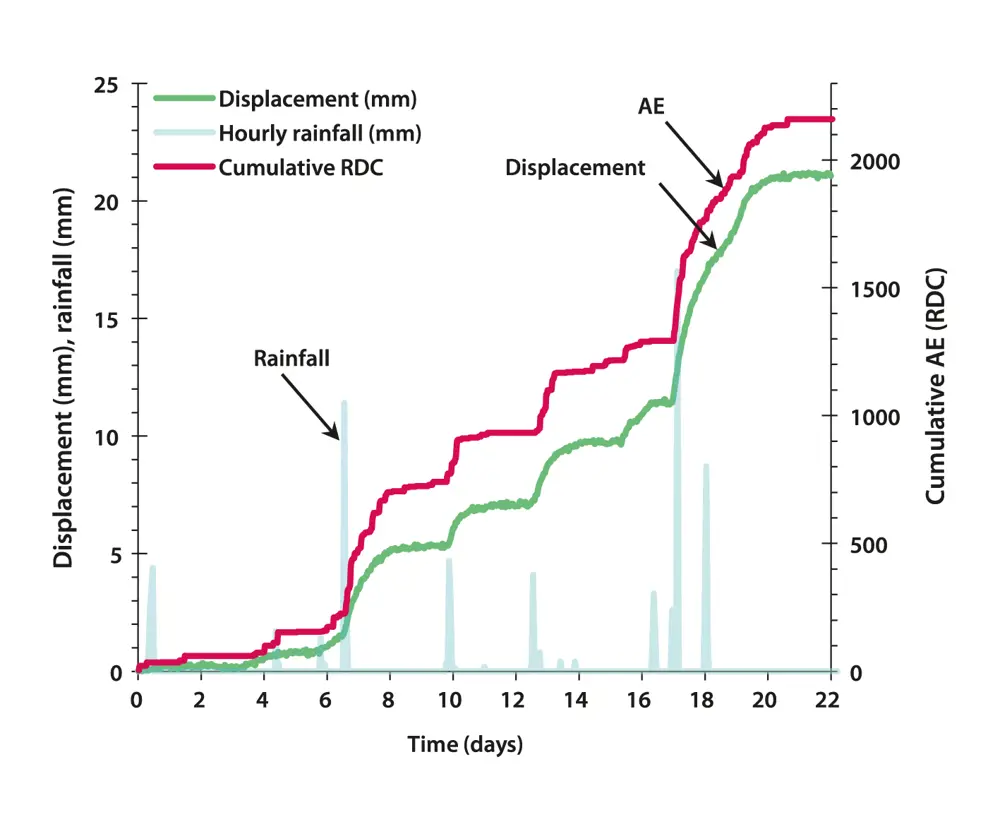
Measurements from a field trial at a landslide in North Yorkshire, UK. The periods of rainfall reduced the slope’s stability, causing surges of slope movement. Subsurface displacement was measured using a Shape Accelerometer Array. The measurements confirm that acoustic emission (AE) activity is directly related to the magnitude and rate of slope movement
Pros and Cons of the high-frequency measurement
Besides offering a system of real time and continuous as opposed to delayed and episodic monitoring of unstable ground, the Loughborough device is easy to install and use, and cheaper than alternative methods. Given that many of the countries most troubled by landslides are also impoverished, one of the team’s aims from the outset was to develop a relatively inexpensive system. Indeed, Smith and team’s plan with RST is to develop a more basic and affordable version of the currently marketed model: one that should make acoustic emissions detection more available to developing countries.
While these high-frequency measurements can flag up worrisome increases in the rate of movement of unstable soil, they cannot reveal the extent of that movement. But an upswing in activity would trigger the deployment of other methods designed to make these assessments.
Monitoring Infrastructure with ground-derived acoustic emissions
Using ground-derived acoustic emissions to monitor potential landslides is still the team’s only commercial application. However, they are also looking at applying the underpinning technology to measure movements in the ground supporting and surrounding buried infrastructure, such as tunnels and pipelines, which could be susceptible to damage.
This much wider exploitation of high-frequency sound would rely on using the buried structure itself as part of the instrument: as a waveguide to respond to acoustic emissions and propagate them to attached sensors. The number of sensors that investigators would attach to a structure would depend on the nature of the surrounding soil. Pipe or tunnel sensors might be needed every 100 metres or so – but it could be more or less than this depending on a geological assessment of the hazards posed by the ground in a particular region.

Illustration of the acoustic emission (AE) monitoring concept applied to buried pipelines. The example shows a fault-rupture deforming a buried pipeline. AE is generated by soil deformation and soil/structure interaction, which propagates as guided waves along the pipeline to the monitoring sensors. The monitoring system interprets the AE and sends a warning to decision makers via telemetry
Interest in acoustic emissions emerged 60 or more years ago, and their use in nondestructive testing and the evaluation of materials has become widespread. But the technology and, in particular, the computing power then available were not up to the task of interpreting the complexity of acoustic emissions generated by ground movements. Until recently, the only conclusions that researchers could draw with any certainty were qualitative: that the ground in which the infrastructure was buried either was or was not stable. The extent of any instability, and the consequential risks to that structure, were impossible to assess. This severely limited the value of acoustic emission measurements to geotechnical engineers. Only with advances in data storage and analysis did it become possible to monitor in the field for long periods and use the accumulated emissions data to reach a quantitative estimate of the risk posed by ground movement.
This approach is still at an early stage, and the hurdles that the Loughborough team has to overcome are considerable. As already explained, interpretation of acoustic emissions from a landslip detector are simplified by a knowledge of the uniform backfill by which its metal tube is surrounded. Sensors attached to buried infrastructure have no such advantage. The soil particles interacting with its surfaces will be of mixed and unknown nature and geometry, will vary from one geographical location to another, and may even do so from point to point on the same structure.
Experimental analysis to build resilient infrastructure
Smith and other researchers are already tackling these hurdles using laboratory simulations. With buried pipes, for example it is possible to record the acoustic emissions generated at their surfaces while the materials with which they’re surrounded are subjected to artificially induced movements. This makes it is possible for researchers to investigate the effect of ground deformation on different materials in different soil types. In the long run, analysis of the recorded emissions should allow operators to assess the degree to which ground movements might affect the infrastructure in that locality, and so the extent of the threat to it. Of course, given the real-world diversity of the ground types in which infrastructure can be buried, there is a deal of painstaking work still to be done.
Smith envisages a time when many forms of buried infrastructure will be routinely fitted with acoustic sensors: the advent, in other words, of smart structures in which integrity is monitored throughout their lifespan
While acknowledging that listening to infrastructure is still a project in its infancy, Smith envisages a time when many forms of buried infrastructure will be routinely fitted with acoustic sensors: the advent, in other words, of smart structures in which integrity is monitored throughout their lifespan. He compares this to the use of sensors to monitor the health of the human body. Ideally, he says, sensors would be incorporated in the infrastructure at the time of its installation. But he also sees a place for the retrofitting of sensors, a task that should prove relatively straightforward.
The exploitation of acoustic emissions monitoring aligns closely with the contemporary emphasis on sustainability. Monitoring not only the integrity of infrastructure, but also the risks to it posed by changes in the environment in which it is buried, opens the way to more targeted and proactive maintenance. This should extend the life of the structure, and so avoid the need for premature and wasteful replacement. Smith quotes, with approval, the opening words of the UN’s Sustainable Development Goal number nine: “Build resilient infrastructure…” That neatly summaries his own goal.
***
This article has been adapted from "The sound before the slide", which originally appeared in the print edition of Ingenia 89 (December 2021).
Contributors
Professor Neil Dixon has over 35 years of experience in geotechnical engineering research and practice. He has published over 190 refereed publications and supervised 33 PhD students in areas including slope stability, landfill barrier design and climate change impacts. He co-invented acoustic emission landslide early-warning systems.
Dr Alister Smith leads the Listening to Infrastructure research programme, which is developing acoustic emission monitoring for geotechnical engineering. Alister’s research has been funded by an EPSRC Fellowship and the Philip Leverhulme Prize. He co-invented acoustic emission landslide early-warning systems. He is the recipient of a series of awards including the Telford Premium and Hawley Award.
Get a free monthly dose of engineering innovation in your inbox
SubscribeRelated content
Civil & structural

Building the Shard
The Shard is one of London's most iconic buildings. The tallest in Western Europe, it was designed by Italian architect Renzo Piano and dominates the city’s skyline. Ingenia spoke to John Parker, project director for structural engineers WSP, who outlined the engineering decisions made in building the enormous steel and glass structure.

The return of arched bridges
Arch bridges are strong, durable and require little maintenance. However, very few had been built since the early 1900s until the FlexiArch was developed and launched in 2007. Now, there has been a minor renaissance for this ancient form of construction.

Creating user-friendly buildings
For Michelle McDowell, a former Business Woman of the Year, a passion for joined-up design thinking and building information modelling with a user-friendly approach has enabled her to pioneer revolutionary changes in her field.

Troja Bridge
In November 2014, one of the world’s largest network arch bridges was officially opened in Prague. The UK may soon have its first network arch bridge if the go-ahead is given for a new rail project in Manchester.
Other content from Ingenia
Quick read

- Environment & sustainability
- Opinion
A young engineer’s perspective on the good, the bad and the ugly of COP27
- Environment & sustainability
- Issue 95
How do we pay for net zero technologies?
Quick read

- Transport
- Mechanical
- How I got here
Electrifying trains and STEMAZING outreach

- Civil & structural
- Environment & sustainability
- Issue 95